
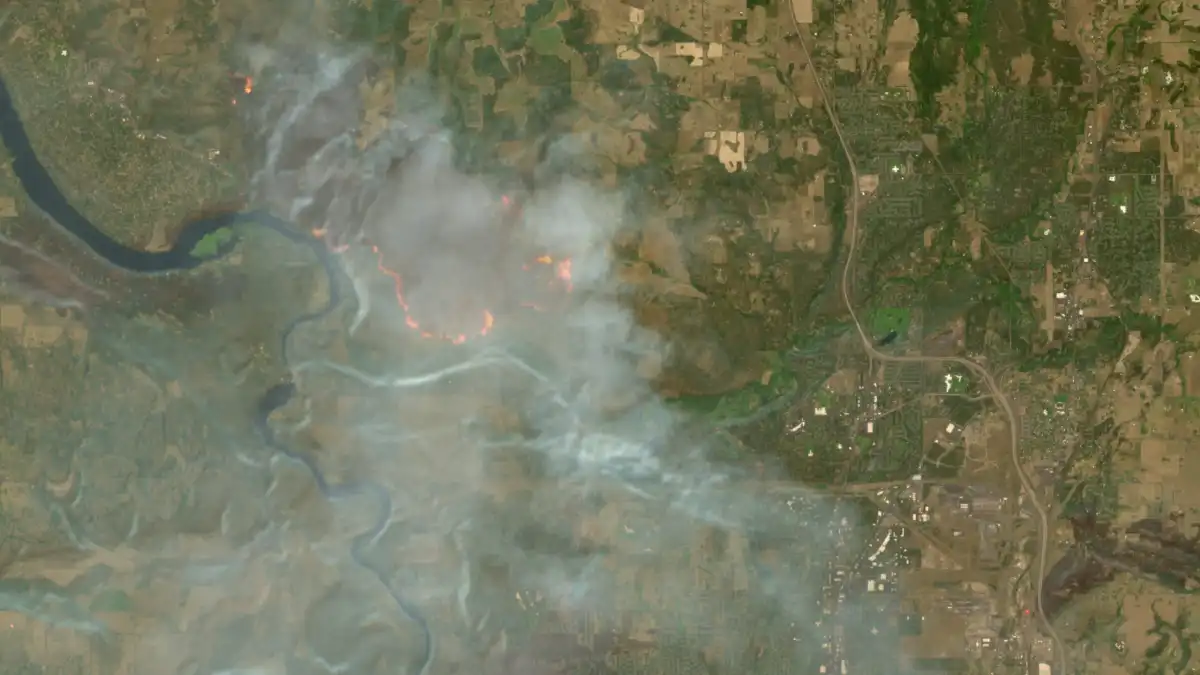
European Space Agency’s Sentinel-2 mission has enhanced its Copernicus Browser with a new default "wildfires" visualization layer, simplifying access to high-resolution satellite imagery for fire monitoring. This integration, which went live on August 4, allows users to quickly identify active fires, burning vegetation, and burned landscapes, leveraging a JavaScript script developed by remote sensing expert Pierre Markuse. For adult industry platforms, this development underscores the growing importance of accessible, high-resolution geospatial data for infrastructure planning, disaster preparedness, and potentially, content moderation and risk assessment in geographically diverse operational areas.
Enhancing Geospatial Data Accessibility for Platform Operators
The Copernicus Browser provides free access to satellite imagery from the European Space Agency’s Sentinel satellites, part of the European Union’s Earth observation program. The Sentinel-2 mission, specifically, offers multi-spectral imaging at resolutions as granular as 10 meters in visible light and near-infrared bands, making it a valuable resource for detailed environmental monitoring. Previously, the browser offered 10 default visualization layers. The addition of the "wildfires" layer as a default option streamlines the process of obtaining critical information, which was previously only accessible by manually copying and pasting Markuse’s JavaScript script into custom visualization options.
This technical upgrade is significant for any industry reliant on robust infrastructure and data center operations, including the adult industry. Understanding environmental risks like wildfires, which can disrupt power grids, internet infrastructure, and physical data centers, is crucial for maintaining uptime and service continuity. High-resolution imagery, updated every few days, offers a level of detail that can inform risk assessments for server locations, network pathways, and personnel safety in regions prone to such events. The ability to quickly visualize active fires in white or yellow, burning vegetation in red, and burned landscapes in dark brown or black provides actionable intelligence for disaster planning and response.

The Technical Underpinnings of the Wildfire Visualization Layer
The "wildfires" visualization layer is based on a JavaScript script by remote sensing expert Pierre Markuse. This script intelligently combines specific spectral bands from the Sentinel-2 imagery to create a clear visual representation of fire activity. It uses the red visible light band, a narrow near-infrared band to highlight differences between healthy and burned vegetation, and the short-wave infrared 2 band to reveal burned landscapes by indicating moisture levels in the soil. This multi-spectral approach allows for a nuanced distinction between various stages and impacts of a wildfire, from active flames to scorched earth.
Simon Proud, a mission scientist for Sentinel-2 at the European Space Agency, was instrumental in pushing for the integration of this script as a default option within the Copernicus Browser. His announcement of the integration was made in a Discord channel on a server run by the investigative journalism group Bellingcat. This collaborative effort, moving a custom script to a widely accessible default feature, exemplifies how community-driven technological solutions can be integrated into broader public services, enhancing their utility and reach. For developers and engineers in the adult industry, this highlights the potential for open-source contributions and community engagement to drive improvements in critical infrastructure monitoring tools.
Comparing Satellite Data for Operational Resilience
While Sentinel-2 offers high-resolution imagery, other satellite constellations and tools also contribute to wildfire monitoring. NASA’s FIRMS tool provides free access to a global map of fires detected by NASA satellite sensors, with rapid updates within several hours. However, NASA satellite imagery is typically available in coarser resolutions, down to 250 meters. By contrast, Sentinel-2 imagery, though updated every few days, provides significantly higher resolution down to a 10-meter spatial resolution in certain bands. This makes Sentinel-2 arguably the best free and publicly available tool for delivering higher-resolution satellite imagery for detailed observation.
The choice between rapid updates at lower resolution (like NASA FIRMS) and less frequent updates at higher resolution (like Sentinel-2) depends on the specific operational need. For adult industry platforms, which often operate globally and rely on distributed infrastructure, a combination of these data sources could be beneficial. Rapid, coarser data might offer early warnings of large-scale events, while detailed, higher-resolution data could be used for more precise impact assessments on specific server farms, network nodes, or even for assessing risks to remote content creation facilities. The European Forest Fire Information System (EFFIS), part of Copernicus EMS, also uses underlying data from NASA MODIS/VIIRS active-fire hotspots combined with EFFIS burnt-area perimeters and the Fire Weather Index danger forecast, updated several times a day, to provide live fire data across Europe.
Implications for Global Infrastructure and Risk Management
The increasing frequency and intensity of wildfires globally, exacerbated by climate change, present significant challenges for maintaining robust digital infrastructure. Regions like Washington, Oregon, Canada, France, and Spain have experienced severe wildfire seasons, leading to evacuations and widespread disruption. For adult industry platforms, which depend on uninterrupted streaming, data storage, and network connectivity, these environmental threats are not abstract; they represent tangible risks to business continuity and data integrity. The ability to monitor these events with precision allows for proactive measures, such as rerouting traffic, activating disaster recovery plans, or deploying mobile infrastructure.
Beyond direct physical threats, the availability of high-resolution geospatial data can also inform broader strategic decisions. For instance, when considering new data center locations or expanding network infrastructure, detailed environmental risk assessments, including wildfire susceptibility, become critical. The free and open access to tools like the Copernicus Browser empowers platform operators to integrate sophisticated environmental intelligence into their risk management frameworks without incurring prohibitive costs. This democratized access to advanced earth observation data is a boon for any industry that needs to build and maintain resilient digital services in an increasingly volatile global environment.